
Puthukkad topographic map
Interactive map
Click on the map to display elevation.
About this map
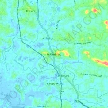
Name: Puthukkad topographic map, elevation, terrain.
Average elevation: 11 m
Minimum elevation: -3 m
Maximum elevation: 76 m
Other topographic maps
Click on a map to view its topography, its elevation and its terrain.
Muriyad
India > Kerala > Mukundapuram > Avittathur
Muriyad, Avittathur, Mukundapuram, Thrissur District, Kerala, 680305, India
Average elevation: 8 m
Velayanad
India > Kerala > Mukundapuram > Vellangallur
Velayanad, Vellangallur, Mukundapuram, Thrissur District, Kerala, 680662, India
Average elevation: 14 m
Irinjalakuda
India > Kerala > Mukundapuram
Irinjalakuda, Mukundapuram, Thrissur, Kerala, 680100, India
Average elevation: 7 m
Kottenelloor
India > Kerala > Mukundapuram > Kottenelloor
Kottenelloor, Mukundapuram, Thrissur district, Kerala, 680672, India
Average elevation: 12 m
vellangallur
India > Kerala > Mukundapuram > Vellangallur
vellangallur, Vellangallur, Mukundapuram, Thrissur district, Kerala, 680662, India
Average elevation: 11 m
manjaly davis ,vendore owned pond
India > Kerala > Mukundapuram > Puthukkad
manjaly davis ,vendore owned pond, Puthukkad, Mukundapuram, Thrissur District, Kerala, India
Average elevation: 13 m