
Inverness topographic map
Interactive map
Click on the map to display elevation.
About this map
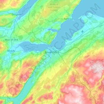
Name: Inverness topographic map, elevation, terrain.
Location: Inverness, Highland, Scotland, IV1 1PQ, United Kingdom (57.31901 -4.38574 57.63901 -4.06574)
Average elevation: 163 m
Minimum elevation: -1 m
Maximum elevation: 615 m
Other topographic maps
Click on a map to view its topography, its elevation and its terrain.
Lochcarron
United Kingdom > Scotland > Highland
Lochcarron, Highland, Scotland, IV54 8YD, United Kingdom
Average elevation: 67 m
Glencoe
United Kingdom > Scotland > Highland
Glencoe, Highland, Scotland, PH49 4HS, United Kingdom
Average elevation: 114 m
Fort William
United Kingdom > Scotland > Highland
Fort William, Highland, Scotland, PH33 6AQ, United Kingdom
Average elevation: 122 m
Ben Nevis
United Kingdom > Scotland > Highland
Ben Nevis, Highland, Scotland, United Kingdom
Average elevation: 912 m