
Gunung Belawar topographic map
Interactive map
Click on the map to display elevation.
About this map
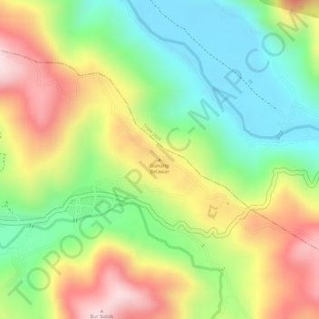
Name: Gunung Belawar topographic map, elevation, terrain.
Location: Gunung Belawar, Terangon, Gayo Lues, Aceh, Indonesia (4.08075 97.07245 4.08085 97.07255)
Average elevation: 810 m
Minimum elevation: 648 m
Maximum elevation: 999 m
Other topographic maps
Click on a map to view its topography, its elevation and its terrain.
Lapangan Terbang
Indonesia > Aceh > Lapangan Terbang
Lapangan Terbang, Pegasing, Aceh Tengah, Aceh, Indonesia
Average elevation: 1,387 m
Mount Leuser
Mount Leuser, Kuta Panjang, Gayo Lues, Aceh, Indonesia
Average elevation: 2,556 m
Gunung Mugajah
Gunung Mugajah, Serbajadi, Aceh Timur, Aceh, Indonesia
Average elevation: 2,189 m
Gunung Bandahara
Gunung Bandahara, Putri Betung, Gayo Lues, Aceh, Indonesia
Average elevation: 2,634 m