
Matale topographic map
Interactive map
Click on the map to display elevation.
About this map
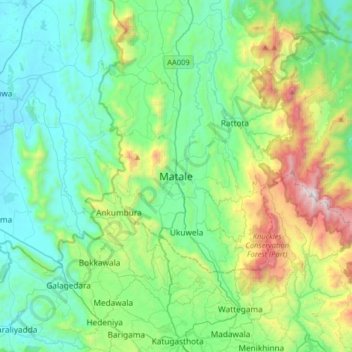
Name: Matale topographic map, elevation, terrain.
Location: Matale, Matale District, Central Province, 25000, Sri Lanka (7.31205 80.46343 7.63205 80.78343)
Average elevation: 532 m
Minimum elevation: 125 m
Maximum elevation: 1,862 m
Other topographic maps
Click on a map to view its topography, its elevation and its terrain.
Hunasgiriya
Sri Lanka > Central Province > Matale
Hunasgiriya, Matale, Matale District, Central Province, Sri Lanka
Average elevation: 996 m