
Aitkin County topographic map
Interactive map
Click on the map to display elevation.
About this map
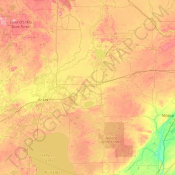
Name: Aitkin County topographic map, elevation, terrain.
Location: Aitkin County, Minnesota, USA (46.15371 -93.81142 47.03159 -93.04948)
Average elevation: 385 m
Minimum elevation: 307 m
Maximum elevation: 480 m
Other topographic maps
Click on a map to view its topography, its elevation and its terrain.
Lake Harriet
USA > Minnesota > Minneapolis
Lake Harriet, Lake Harriet Bike Trail, Lynnhurst, Minneapolis, Hennepin County, Minnesota, 55410, USA
Average elevation: 268 m
Keller Lake
Keller Lake, North Maplewood Drive, Maplewood, Ramsey County, Minnesota, 55109, USA
Average elevation: 272 m
Current Lake
USA > Minnesota > Current Lake
Current Lake, Murray County, Minnesota, USA
Average elevation: 511 m
Alexandria
USA > Minnesota > Alexandria
Alexandria, Douglas County, Minnesota, 56308, USA
Average elevation: 426 m
Beauty Lake
Beauty Lake, South Beauty Lane, Itasca County, Minnesota, USA
Average elevation: 421 m