
Baker Beach topographic map
Interactive map
Click on the map to display elevation.
About this map
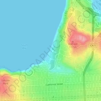
Name: Baker Beach topographic map, elevation, terrain.
Average elevation: 36 m
Minimum elevation: -1 m
Maximum elevation: 126 m
Other topographic maps
Click on a map to view its topography, its elevation and its terrain.
Ocean Beach
USA > California > San Francisco
Ocean Beach, Great Highway, Sunset District, San Francisco, San Francisco City and County, California, 94166, USA
Average elevation: 21 m
Farallon Islands
USA > California > San Francisco
Farallon Islands, San Francisco, San Francisco City and County, California, USA
Average elevation: 0 m
Bernal Heights Park
USA > California > San Francisco
Bernal Heights Park, Bernal Heights, San Francisco, San Francisco City and County, California, USA
Average elevation: 36 m