
Make a donation
Mulugu topographic map
Click on the map to display elevation.
Make a donation
About this map
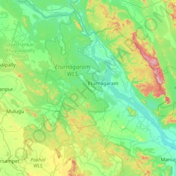
Name: Mulugu topographic map, elevation, terrain.
Location: Mulugu, Telangana, India (17.99623 79.81476 18.63291 80.79027)
Average elevation: 203 m
Minimum elevation: 48 m
Maximum elevation: 928 m
Make a donation
Other topographic maps
Click on a map to view its topography, its elevation and its terrain.
Make a donation
Make a donation
Secunderabad
Situated in the North of Hyderabad at 17°27′N 78°30′E / 17.45°N 78.5°E / 17.45; 78.5, Secunderabad lies on the northern part of the Deccan Plateau. Secunderabad has an average elevation of 543 metres (1781 ft). Most of the area has a rocky terrain and some areas are hilly.
Average elevation: 544 m
Make a donation
Make a donation
Make a donation
Make a donation
Make a donation
Bhongir
India > Telangana > Bhongiri mandal
Bhongir is located at 17°30′39″N 78°53′20″E / 17.5108°N 78.8889°E / 17.5108; 78.8889. It has an average elevation of 329 metres (1,079 ft).
Average elevation: 447 m
Nakrekal
India > Telangana > Nakrekal mandal
Nakrekal is located at 17°09′53″N 79°25′39″E / 17.16469834°N 79.42747827°E / 17.16469834; 79.42747827. It has an average elevation of 240 metres (790 ft).
Average elevation: 207 m
Make a donation
Godavarikhani Bus-Stand
India > Telangana > Ramagundam mandal > Godavari Khani
Average elevation: 148 m
Make a donation
Make a donation
Nallamala Forest
India > Telangana > Tirumalagiri_Sagar mandal > Garkanattu Thanda
Average elevation: 122 m
Make a donation
Make a donation
Ramagundam
India > Telangana > Ramagundam mandal
Ramagundam is located at 18°45′50″N 79°28′30″E / 18.7638°N 79.4750°E / 18.7638; 79.4750. It has an average elevation of 179 meters (590 feet). It is about 225 kilometres (140 mi) northeast of the state capital, Hyderabad, 65 km from Karimnagar, 0 km from Ramagundam district headquarters…
Average elevation: 174 m
Durgam Cheruvu Secret Lake Park
India > Telangana > Serilingampalle mandal > Hyderabad
Average elevation: 579 m
Make a donation
Make a donation
Make a donation
Warangal
India > Telangana > Warangal mandal
Warangal is located at 18°00′N 79°35′E / 18.0°N 79.58°E / 18.0; 79.58. It has an average elevation of 302 metres (990 feet). It is settled in the eastern part of Deccan Plateau made up of granite rocks and hill formations which left the region barren making the cultivation dependent on…
Average elevation: 268 m
Make a donation
Make a donation
Make a donation
Make a donation
Make a donation
Make a donation
Bhadrachalam
Bhadrachalam is located at 17°40′N 80°53′E / 17.67°N 80.88°E / 17.67; 80.88. It has an average elevation of 50 metres (164 feet). The zero feet gauge level of Godavari River at Bhadracham is equal to +32.6 m msl.
Average elevation: 52 m
Make a donation
Make a donation
Mahbubnagar
India > Telangana > Mahabubnagar_Urban mandal
Mahbubnagar is located at 16°44′N 77°59′E / 16.73°N 77.98°E / 16.73; 77.98. It has an average elevation of 498 metres (1633 feet). The city of Mahbubnagar is located at a distance of 98 km from Hyderabad, 130 km from Kurnool and 151 km from Gulbarga.
Average elevation: 509 m
Make a donation
Make a donation