
Nottingham topographic map
Interactive map
Click on the map to display elevation.
About this map
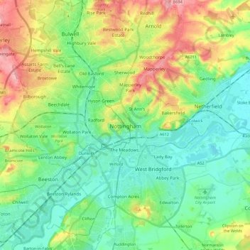
Name: Nottingham topographic map, elevation, terrain.
Location: Nottingham, Nottinghamshire, England, United Kingdom (52.88901 -1.24696 53.01867 -1.08612)
Average elevation: 56 m
Minimum elevation: 16 m
Maximum elevation: 140 m
Other topographic maps
Click on a map to view its topography, its elevation and its terrain.
Granby
United Kingdom > England > Nottinghamshire > Rushcliffe
Granby, Sutton, Rushcliffe, Nottinghamshire, England, United Kingdom
Average elevation: 32 m
Newark and Sherwood
United Kingdom > England > Nottinghamshire
Newark and Sherwood, Nottinghamshire, England, United Kingdom
Average elevation: 49 m
Retford
United Kingdom > England > Nottinghamshire > Bassetlaw
Retford, Bassetlaw, Nottinghamshire, England, DN22 6DW, United Kingdom
Average elevation: 31 m