
Make a donation
Cherupuzha topographic map
Click on the map to display elevation.
Make a donation
Cherupuzha
Surrounded by green terrains and mesmerizing hills, Tejaswini river in Cherupuzha offers adventurous tourist activity like white water rafting in Western ghats. Kollada near Cherupuzha is the starting point to kick off the rafting trip on the river. The rafting experience at Cherupuzha is an ideal stepping stone for those who aspires challenging high altitude rapids. Inflatable rafts are used here which is less expensive and easily maintained. White Water Rafting at Tejaswini river is one of the 17 best places for rafting in India.
Make a donation
About this map
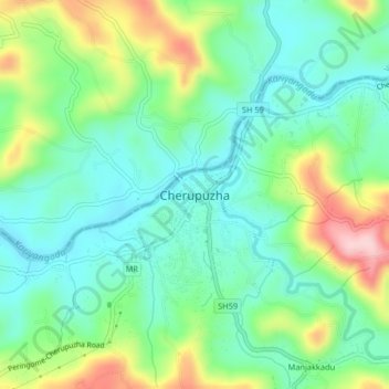
Name: Cherupuzha topographic map, elevation, terrain.
Average elevation: 124 m
Minimum elevation: 21 m
Maximum elevation: 408 m
Make a donation
Other topographic maps
Click on a map to view its topography, its elevation and its terrain.