
Lalganj topographic map
Interactive map
Click on the map to display elevation.
About this map
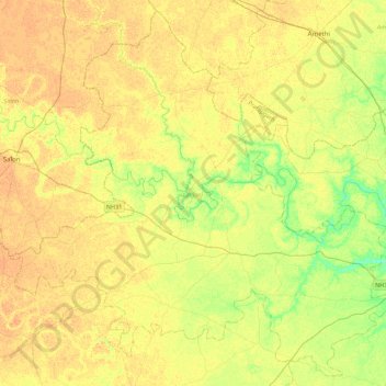
Name: Lalganj topographic map, elevation, terrain.
Location: Lalganj, Pratapgarh, Uttar Pradesh, India (25.80515 81.45277 26.18117 81.89363)
Average elevation: 103 m
Minimum elevation: 86 m
Maximum elevation: 112 m
Other topographic maps
Click on a map to view its topography, its elevation and its terrain.
Raniganj
India > Uttar Pradesh > Pratāpgarh
Raniganj, Pratapgarh, Uttar Pradesh, India
Average elevation: 94 m
.1
India > Uttar Pradesh > Pratāpgarh
.1, Kunda, Pratapgarh, Uttar Pradesh, 229408, India
Average elevation: 106 m
Pratāpgarh
India > Uttar Pradesh > Pratāpgarh
Pratāpgarh, Pratapgarh, Uttar Pradesh, India
Average elevation: 103 m