
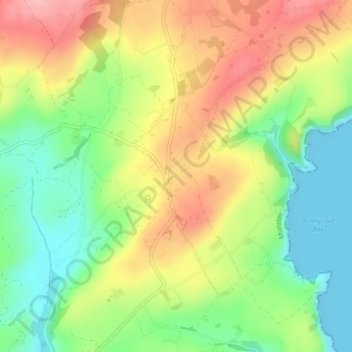
Ardfield topographic map
Interactive map
Click on the map to display elevation.
About this map
Name: Ardfield topographic map, elevation, terrain.
Average elevation: 62 m
Minimum elevation: -1 m
Maximum elevation: 134 m
Other topographic maps
Click on a map to view its topography, its elevation and its terrain.
Rockfort
Rockfort, Brinny ED, The Municipal District of Bandon-Kinsale, County Cork, Munster, Ireland
Average elevation: 53 m
Ballyshoneen
Ireland > County Cork > Municipal District of Macroom
Ballyshoneen, Dripsey, Municipal District of Macroom, County Cork, Munster, Ireland
Average elevation: 120 m
Castlemartyr
Castlemartyr, Castlemartyr ED, The Municipal District of East Cork, County Cork, Munster, Ireland
Average elevation: 16 m
Fermoyle
Fermoyle, Banteer ED, The Municipal District of Kanturk – Mallow, County Cork, Munster, Ireland
Average elevation: 193 m