
Ghumarwin topographic map
Interactive map
Click on the map to display elevation.
About this map
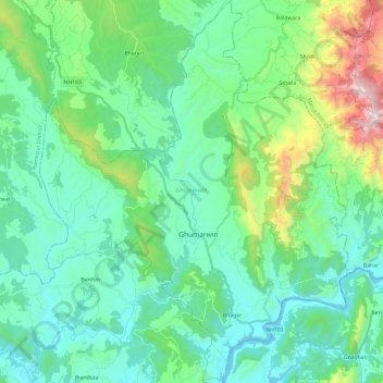
Name: Ghumarwin topographic map, elevation, terrain.
Location: Ghumarwin, Bilaspur, Himachal Pradesh, India (31.36262 76.60792 31.56707 76.80162)
Average elevation: 774 m
Minimum elevation: 486 m
Maximum elevation: 1,857 m
Other topographic maps
Click on a map to view its topography, its elevation and its terrain.
Berthin
India > Himachal Pradesh > Bilaspur
Berthin, Bilaspur, Himachal Pradesh, 174029, India
Average elevation: 621 m
Bilaspur
India > Himachal Pradesh > Bilaspur
Bilaspur, Himachal Pradesh, 174001, India
Average elevation: 738 m
Naina Devi
India > Himachal Pradesh > Bilaspur
Naina Devi, Bilaspur, Himachal Pradesh, India
Average elevation: 490 m