
Jhumri Tilaiya topographic map
Interactive map
Click on the map to display elevation.
About this map
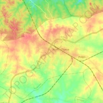
Name: Jhumri Tilaiya topographic map, elevation, terrain.
Location: Jhumri Tilaiya, Koderma, Kodarma, Jharkhand, 825409, India (24.39303 85.48168 24.47303 85.56168)
Average elevation: 388 m
Minimum elevation: 356 m
Maximum elevation: 412 m
Jhumri Telaiya is located in the Damodar River valley, North Chotanagpur Division. It has an average elevation of 383 m (1,257 ft). It is situated about eight kilometres from Koderma. Both the towns are closely linked.some day going to be one big urban zone in Jharkhand. The entire town is divided by the grand cord line of Eastern Railway, which passes through the middle of the town.