
Far-Western Development Region topographic map
Interactive map
Click on the map to display elevation.
About this map
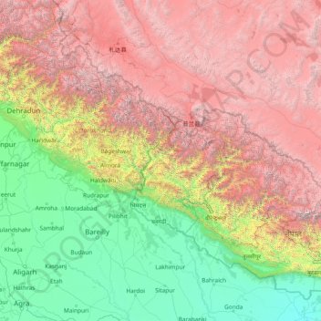
Name: Far-Western Development Region topographic map, elevation, terrain.
Location: Far-Western Development Region, Nepal (26.97105 78.00673 32.17105 83.20673)
Average elevation: 2,505 m
Minimum elevation: 76 m
Maximum elevation: 7,878 m
The Far-Western Region covered 19,539 square kilometers. It had nine districts with the regional headquarters at Attariya, Kailali District. The Far-Western Region was remote and developmentally challenged. Some 44% of people in the Far West Hills and 49% in the Himalayan districts lived below the poverty line. The region had limited basic services. The difficult topography complicated development. The region had complex socio-economic structures along with widespread gender- and caste-based discrimination. Traditional systems associated with religion, culture and customs had limited overall development.
Other topographic maps
Click on a map to view its topography, its elevation and its terrain.
Ilam
Nepal > Koshi Province > Ilam
Ilam, Illam, Ilam, Koshi Province, 57300, Nepal
Average elevation: 919 m
Simjung
Nepal > Gandaki Province > Gorkha
Simjung, Ajirkot, Gorkha, Gandaki Province, Nepal
Average elevation: 1,619 m
Sauraha Chok
Nepal > Bagmati Province > Chitwan > Ratnanagar
Sauraha Chok, Ratnanagar-01, Ratnanagar, Chitwan, Bagmati Province, 44204, Nepal
Average elevation: 197 m
Mount Everest
Nepal > Koshi Province > Solukhumbu
Mount Everest, Khumbupasanglahmu, Solukhumbu, Koshi Province, Nepal
Average elevation: 7,847 m
Premnagar
Nepal > Madhesh Province > Mahottari
Premnagar, Bardibas, Mahottari, Madhesh Province, Nepal
Average elevation: 141 m
Dambiodar village
Nepal > Bagmati Province > Nuwakot
Dambiodar village, Ducheshwar-01, Ducheshwar, Nuwakot, Bagmati Province, Nepal
Average elevation: 1,777 m
Parbati Kunda
Nepal > Bagmati Province > Rasuwa
Parbati Kunda, Rasuwa, Bagmati Province, Nepal
Average elevation: 3,310 m
Khopi
Nepal > Koshi Province > Taplejung
Khopi, Sidingba-07, Sidingba, Taplejung, Koshi Province, Nepal
Average elevation: 1,852 m
Bharatpur
Nepal > Bagmati Province > Chitwan
Bharatpur, Chitwan, Bagmati Province, Nepal
Average elevation: 381 m
Phaplu
Nepal > Koshi Province > Solukhumbu
Phaplu, Solududhkunda, Solukhumbu, Koshi Province, 50600, Nepal
Average elevation: 2,518 m
Dhanpalthan
Nepal > Koshi Province > Morang
Dhanpalthan, Morang, Koshi Province, Nepal
Average elevation: 71 m
Simi Gaun
Nepal > Bagmati Province > Dolakha
Simi Gaun, Gaurishankar, Dolakha, Bagmati Province, Nepal
Average elevation: 2,103 m
Malibara
Nepal > Madhesh Province > Mahottari
Malibara, Jaleswar, Mahottari, Madhesh Province, 45700, Nepal
Average elevation: 63 m
Achham
Nepal > Sudurpashchim Province
Achham, Sudurpashchim Province, 10709, Nepal
Average elevation: 1,387 m
Tumling
Nepal > Koshi Province > Ilam
Tumling, 03DR020, Sandakpur-05, Sandakpur, Ilam, Koshi Province, Nepal
Average elevation: 2,759 m
Tingla
Nepal > Koshi Province > Solukhumbu
Tingla, Nechasalyan-06, Nechasalyan, Solukhumbu, Koshi Province, Nepal
Average elevation: 1,843 m
Pokhra
Nepal > Karnali Province > Dailekh
Pokhra, Gurans-02, Gurans, Dailekh, Karnali Province, Nepal
Average elevation: 1,106 m
Pathari
Nepal > Koshi Province > Morang
Pathari, Patahrishanishchare, Morang, Koshi Province, 56600, Nepal
Average elevation: 139 m
Annapurna
Nepal > Gandaki Province > Kaski
Annapurna, Kaski, Gandaki Province, 33711, Nepal
Average elevation: 2,974 m
Chautari
Nepal > Gandaki Province > Kaski > Baskharka
Chautari, Annapurna-04, Baskharka, Annapurna, Kaski, Gandaki Province, Nepal
Average elevation: 1,521 m
Pipalla Bazar
Pipalla Bazar, Dipayal Silgadi-04, Dipayal, Dipayal Silgadi, Doti, Nepal
Average elevation: 614 m
Muktinath
Nepal > Gandaki Province > Mustang > Ranipauwa
Muktinath, Barhagaun Muktikhsetra-01, Ranipauwa, Barhagaun Muktikhsetra, Mustang, Gandaki Province, 33100, Nepal
Average elevation: 3,965 m
Kanchanpur
Kanchanpur, Ramgopalpur, Mahottari, Madhesh Province, Nepal
Average elevation: 90 m
Lalitpur
Nepal > Bagmati Province > Lalitpur
Lalitpur, Lalitpur Metropolitan City, Lalitpur, Bagmati Province, 44707, Nepal
Average elevation: 1,316 m
Nawalpur
Nawalpur, Indrawati, Sindhupalchowk, Bagmati Pradesh, Nepal
Average elevation: 1,463 m
Thakuri Thana
Thakuri Thana, Rannada, Kotdewal, Masta, Bajhang, Sudurpashchim Pradesh, Nepal
Average elevation: 1,958 m
Rapla
Nepal > Darchula District (Nepal)
Rapla, Byash Municipality, Darchula District (Nepal), Sudurpashchim Pradesh, Nepal
Average elevation: 3,607 m
Musikot
Nepal > Western Rukum District
Musikot, Western Rukum District, Karnali Pradesh, 22000, Nepal
Average elevation: 1,594 m
Lalitpur
Nepal > Central Development Region
Lalitpur, Bagmati, Central Development Region, Nepal
Average elevation: 1,536 m
Musikot
Nepal > Western Rukum District
Musikot, Western Rukum District, Karnali Pradesh, 22000, Nepal
Average elevation: 1,742 m