
Monaragala District topographic map
Interactive map
Click on the map to display elevation.
About this map
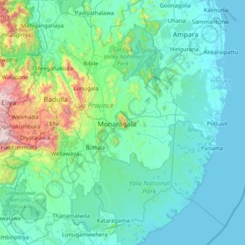
Name: Monaragala District topographic map, elevation, terrain.
Location: Monaragala District, Uva Province, Sri Lanka (6.29647 80.82784 7.45855 81.63715)
Average elevation: 235 m
Minimum elevation: -1 m
Maximum elevation: 2,308 m
Other topographic maps
Click on a map to view its topography, its elevation and its terrain.
Ella
Ella (Sinhala: ඇල්ල, lit. 'fall'; Tamil: எல்ல) is a small town in the Badulla District of Uva Province, Sri Lanka governed by an Urban Council. It is approximately 200 kilometres (120 mi) east of Colombo and is situated at an elevation of 1,041 metres (3,415 ft) above sea level. The area has…
Average elevation: 1,021 m
Bandarawela
Bandarawela (Sinhala : බණ්ඩාරවෙල, pronounced [banˈda:rawela]; Tamil: பண்டாரவளை) is the second largest town in the Badulla District which is 28 km (17 mi) away from Badulla. Bandarawela is 200 km (120 mi) away from Colombo and about 125 km (78 mi) away from Kandy, the two…
Average elevation: 1,293 m