
Anuradhapura District topographic map
Interactive map
Click on the map to display elevation.
About this map
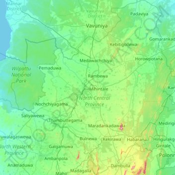
Name: Anuradhapura District topographic map, elevation, terrain.
Location: Anuradhapura District, North Central Province, Sri Lanka (7.81636 79.95230 8.92022 80.99092)
Average elevation: 85 m
Minimum elevation: -1 m
Maximum elevation: 706 m
Other topographic maps
Click on a map to view its topography, its elevation and its terrain.
Kaludiya Pokuna
Sri Lanka > North Central Province > Mihintale > Illuppukanniya
Average elevation: 123 m