
Make a donation
Kegalle District topographic map
Click on the map to display elevation.
Make a donation
About this map
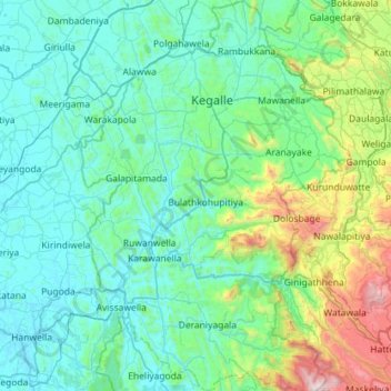
Name: Kegalle District topographic map, elevation, terrain.
Location: Kegalle District, Sabaragamuwa Province, Sri Lanka (6.83001 80.14537 7.39661 80.54813)
Average elevation: 309 m
Minimum elevation: 5 m
Maximum elevation: 1,938 m
Make a donation
Other topographic maps
Click on a map to view its topography, its elevation and its terrain.
Make a donation
Make a donation
Belihuloya
Sri Lanka > Sabaragamuwa Province
Belihuloya is a village in the Ratnapura District, Sabaragamuwa Province of Sri Lanka. It is approximately 150 kilometres (93 mi) south-east of Colombo and is situated at an elevation of 616 metres (2,021 ft) above sea level. This hillside location is a climatically transitional area, linking both the dry and…
Average elevation: 705 m
Make a donation
Make a donation
Make a donation
Rakwana
Sri Lanka > Sabaragamuwa Province
Located at an elevation of 464 m (1,522 ft), north of Sinharaja Mountains, on the A17 highway. It is 12 km (7.5 mi) from Rakwana-Deniyaya on the way to Galle. It also has roads leading to Embilipitiya and Kalawana. Rakwana acts as one of the gateways for the famous Sinharaja Forest reserve.
Average elevation: 609 m
Make a donation
Make a donation
Make a donation
Make a donation
Make a donation
Belihuloya
Sri Lanka > Sabaragamuwa Province
Belihuloya is a village in the Ratnapura District, Sabaragamuwa Province of Sri Lanka. It is approximately 150 kilometres (93 mi) south-east of Colombo and is situated at an elevation of 616 metres (2,021 ft) above sea level. This hillside location is a climatically transitional area, linking both the dry and…
Average elevation: 705 m
Make a donation
Adam’s Peak
Sri Lanka > Sabaragamuwa Province
For a long period Adam's Peak was supposed to be the highest mountain in Ceylon, but actual survey makes it only 7353 ft. above sea-level. This elevation is chiefly remarkable as the resort of pilgrims from all parts of the East. The hollow in the lofty rock that crowns the summit is said by the Brahmans to be…
Average elevation: 1,739 m
Make a donation
Make a donation
Make a donation
Mawanella
Sri Lanka > Sabaragamuwa Province
Mawanella belongs to the Tropical Evergreen region of central Sri Lanka. The altitude of the area varies from 180m to 260 m above sea level. The average annual rainfall lies between 2500 and 4500 ml, and temperature of the region ranges between 22 degrees and 35 degrees Celsius. It receives most of the rain…
Average elevation: 239 m
Make a donation
Make a donation
Make a donation
Make a donation
Make a donation
Make a donation
Make a donation
Make a donation
Make a donation