
Walsh County topographic map
Interactive map
Click on the map to display elevation.
About this map
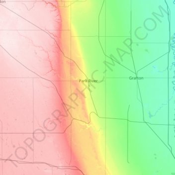
Name: Walsh County topographic map, elevation, terrain.
Location: Walsh County, North Dakota, United States of America (48.19223 -98.31957 48.54331 -97.11465)
Average elevation: 352 m
Minimum elevation: 235 m
Maximum elevation: 512 m
Other topographic maps
Click on a map to view its topography, its elevation and its terrain.
Bottineau County
United States of America > North Dakota
Bottineau County, North Dakota, United States of America
Average elevation: 485 m
Hatton
United States of America > North Dakota > Hatton
Hatton, Traill County, North Dakota, United States of America
Average elevation: 329 m
Mountrail County
United States of America > North Dakota
Mountrail County, North Dakota, United States of America
Average elevation: 659 m