
Muthur topographic map
Interactive map
Click on the map to display elevation.
About this map
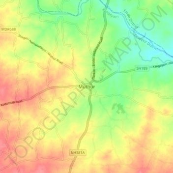
Name: Muthur topographic map, elevation, terrain.
Location: Muthur, Kangeyam, Tiruppur District, Tamil Nadu, 638105, India (11.00366 77.69449 11.08366 77.77449)
Average elevation: 208 m
Minimum elevation: 173 m
Maximum elevation: 239 m
Other topographic maps
Click on a map to view its topography, its elevation and its terrain.
Sivanmalai
India > Tamil Nadu > Kangeyam > Sivanmalai
Sivanmalai, Kangeyam, Tiruppur District, Tamil Nadu, 638701, India
Average elevation: 308 m
Vellakovil
India > Tamil Nadu > Kangeyam > Vellakovil
Vellakovil, Kangeyam, Tiruppur District, Tamil Nadu, 638111, India
Average elevation: 242 m