
Taguig topographic map
Interactive map
Click on the map to display elevation.
About this map
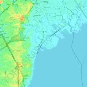
Name: Taguig topographic map, elevation, terrain.
Location: Taguig, Fourth District, Metro Manila, Philippines (14.46494 121.02221 14.56213 121.10852)
Average elevation: 10 m
Minimum elevation: -2 m
Maximum elevation: 59 m
Other topographic maps
Click on a map to view its topography, its elevation and its terrain.
Fort Bonifacio
Fort Bonifacio, Taguig, Southern Manila district, Metro Manila, Philippines
Average elevation: 19 m
New Lower Bicutan
New Lower Bicutan, Taguig, Fourth District, Metro Manila, Philippines
Average elevation: 8 m