GHNP Ropa Complex topographic map
Interactive map
Click on the map to display elevation.
About this map
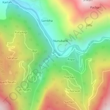
Name: GHNP Ropa Complex topographic map, elevation, terrain.
Average elevation: 1,841 m
Minimum elevation: 1,398 m
Maximum elevation: 2,424 m

Click on the map to display elevation.
Name: GHNP Ropa Complex topographic map, elevation, terrain.
Average elevation: 1,841 m
Minimum elevation: 1,398 m
Maximum elevation: 2,424 m