Davidson County topographic map
Interactive map
Click on the map to display elevation.
About this map
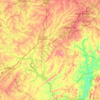
Name: Davidson County topographic map, elevation, terrain.
Location: Davidson County, North Carolina, United States of America (35.50419 -80.48771 36.02694 -80.04323)
Average elevation: 222 m
Minimum elevation: 111 m
Maximum elevation: 350 m
Davidson County is located entirely within the Piedmont region of central North Carolina. The Piedmont consists of gently rolling terrain frequently broken by hills or shallow valleys formed by rivers and streams. An exception to this terrain are the Uwharrie Mountains in the county's western and southwestern sections. The Uwharries are the oldest mountain range in North America, and at one time they rose to nearly 20,000 feet (6,100 m) above sea level. However, time has worn them down to little more than high hills; yet due to the relative flatness of the surrounding countryside they still rise from 250 to 500 feet (150 m) above their base. The highest point in the Uwharries - and the highest point in Davidson County - is High Rock Mountain in the county's southwestern corner. It has an elevation of 1,119 feet (341 m) above sea level.
Other topographic maps
Click on a map to view its topography, its elevation and its terrain.
Lincoln County
United States of America > North Carolina
Lincoln County, North Carolina, United States of America
Average elevation: 266 m
Neuse River
United States of America > North Carolina
Neuse River, Wayne County, North Carolina, 28502, United States of America
Average elevation: 47 m
Graham County
United States of America > North Carolina
Graham County, North Carolina, United States of America
Average elevation: 850 m
Pamlico County
United States of America > North Carolina
Pamlico County, North Carolina, United States of America
Average elevation: 5 m
C N Robertson Pond Dam
United States of America > North Carolina
C N Robertson Pond Dam, Wake County, North Carolina, 27545, United States of America
Average elevation: 103 m
Redwood Village
United States of America > North Carolina > Asheville > Redwood Village
Redwood Village, Asheville, Buncombe County, North Carolina, 22803, United States of America
Average elevation: 657 m
Guilford County
United States of America > North Carolina
Guilford County, North Carolina, United States of America
Average elevation: 239 m
Buncombe County
United States of America > North Carolina
Buncombe County, North Carolina, United States of America
Average elevation: 839 m
Chapel Hill
United States of America > North Carolina > Chapel Hill > Chapel Hill
Chapel Hill, Orange County, North Carolina, United States of America
Average elevation: 125 m
Ashe County
United States of America > North Carolina
Ashe County, North Carolina, United States of America
Average elevation: 950 m
Cataloochee
United States of America > North Carolina > Cataloochee
Cataloochee, Haywood County, North Carolina, United States of America
Average elevation: 998 m
Durham County
United States of America > North Carolina
Durham County, North Carolina, United States of America
Average elevation: 128 m