
Cazorla topographic map
Interactive map
Click on the map to display elevation.
About this map
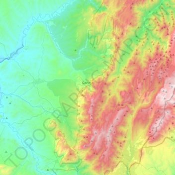
Name: Cazorla topographic map, elevation, terrain.
Location: Cazorla, Jaén, Andalusia, Spain (37.79111 -3.19173 38.01371 -2.77362)
Average elevation: 929 m
Minimum elevation: 360 m
Maximum elevation: 2,057 m
Cazorla lies at an elevation of 836 metres on the western slope of the Sierra de Cazorla. It is the entry point and base for visits to the Natural Park of Sierras de Cazorla, Segura y Las Villas Natural Park, a vast protected area of magnificent river gorges and forests. Spain's second longest river, the Guadalquivir, has its source in the mountains to the south of the settlement.