
Peermade topographic map
Interactive map
Click on the map to display elevation.
About this map
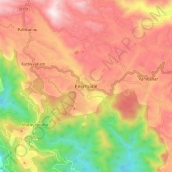
Name: Peermade topographic map, elevation, terrain.
Location: Peermade, Peerumade, Idukki District, Kerala, 685531, India (9.53201 76.95590 9.61201 77.03590)
Average elevation: 918 m
Minimum elevation: 300 m
Maximum elevation: 1,399 m
Other topographic maps
Click on a map to view its topography, its elevation and its terrain.
Periyar National Park Tiger Reserve
Periyar National Park lies in the middle of a mountainous area of the Cardamom Hills. In the north : The boundary commences from the point nearest to the Medaganam in the interstate boundary up to Vellimalai. and the east Thence the boundary follows the inter-state boundary from Vellimalai to Kallimalai Peak…
Average elevation: 929 m