
Michigan topographic map
Interactive map
Click on the map to display elevation.
About this map
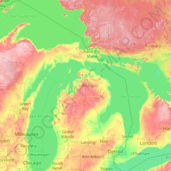
Name: Michigan topographic map, elevation, terrain.
Location: Michigan, United States (41.69613 -90.41862 48.30606 -82.12281)
Average elevation: 259 m
Minimum elevation: 169 m
Maximum elevation: 653 m
The heavily forested Upper Peninsula is relatively mountainous in the west. The Porcupine Mountains, which are part of one of the oldest mountain chains in the world, rise to an altitude of almost 2,000 feet (610 m) above sea level and form the watershed between the streams flowing into Lake Superior and Lake Michigan. The surface on either side of this range is rugged. The state's highest point, in the Huron Mountains northwest of Marquette, is Mount Arvon at 1,979 feet (603 m). The peninsula is as large as Connecticut, Delaware, Massachusetts, and Rhode Island combined but has fewer than 330,000 inhabitants. They are sometimes called "Yoopers" (from "U.P.'ers"), and their speech (the "Yooper dialect") has been heavily influenced by the numerous Scandinavian and Canadian immigrants who settled the area during the lumbering and mining boom of the late 19th century.
Other topographic maps
Click on a map to view its topography, its elevation and its terrain.
Tacoma
United States > Washington > Pierce County
Tacoma, Pierce County, Washington, United States
Average elevation: 67 m
Snohomish County
Snohomish County, Washington, United States
Average elevation: 649 m
Haywood County
United States > North Carolina
Haywood County, North Carolina, United States
Average elevation: 1,044 m
Plano
United States > Illinois > Kendall County
Plano, Little Rock Township, Kendall County, Illinois, 60545, United States
Average elevation: 202 m
Bladen County
United States > North Carolina
Bladen County, North Carolina, United States
Average elevation: 27 m
San Diego
United States > California > San Diego County
San Diego, San Diego County, California, United States
Average elevation: 125 m
Phoenix
United States > Arizona > Maricopa County
Phoenix, Maricopa County, Arizona, United States
Average elevation: 481 m
Rosedale
United States > California > Kern County
Rosedale, Kern County, California, United States
Average elevation: 113 m
Eden
United States > Colorado > Pueblo County > Pueblo
Eden, Pueblo, Pueblo County, Colorado, 81008, United States
Average elevation: 1,472 m
Chino Hills
United States > California > San Bernardino County
Chino Hills, San Bernardino County, California, United States
Average elevation: 255 m
Ashland
United States > Missouri > Boone County
Ashland, Boone County, Missouri, 65010, United States
Average elevation: 262 m
University Place
United States > Washington > Pierce County
University Place, Pierce County, Washington, United States
Average elevation: 72 m
Chelan County
Chelan County, Washington, United States
Average elevation: 1,094 m
Oakland
United States > California > Alameda County
Oakland, Alameda County, California, United States
Average elevation: 51 m
Clyde
United States > Ohio > Sandusky County
Clyde, Sandusky County, Ohio, 43410, United States
Average elevation: 209 m
Barrington
United States > Rhode Island > Bristol County
Barrington, Bristol County, Rhode Island, 02806, United States
Average elevation: 4 m
Mountain Center
United States > California > Riverside County
Mountain Center, Riverside County, California, United States
Average elevation: 1,476 m
Mulino
United States > Oregon > Clackamas County
Mulino, Clackamas County, Oregon, 97042, United States
Average elevation: 100 m
Granger
United States > Iowa > Dallas County
Granger, Dallas County, Iowa, 50109, United States
Average elevation: 274 m
Rio Grande
United States > Texas > Starr County
Rio Grande, Starr County, Texas, United States
Average elevation: 71 m
Pine Forest
United States > Texas > Orange County
Pine Forest, Orange County, Texas, United States
Average elevation: 5 m
Sacramento
United States > California > Sacramento County
Sacramento, Sacramento County, California, United States
Average elevation: 10 m
Morgan Hill
United States > California > Santa Clara County
Morgan Hill, Santa Clara County, California, 95038, United States
Average elevation: 153 m
Points
United States > West Virginia > Hampshire County
Points, Hampshire County, West Virginia, 25437, United States
Average elevation: 334 m
Stark
United States > Minnesota > Brown County
Stark, Brown County, Minnesota, United States
Average elevation: 307 m
Burlington
United States > Connecticut > Northwest Hills Planning Region
Burlington, Northwest Hills Planning Region, Connecticut, 06013, United States
Average elevation: 219 m
San Angelo
United States > Texas > Tom Green County
San Angelo, Tom Green County, Texas, United States
Average elevation: 576 m
Thomas Mountain
United States > California > Riverside County
Thomas Mountain, Riverside County, California, 92361, United States
Average elevation: 1,834 m
Thomas Mountain
United States > Connecticut > Western Connecticut Planning Region > Danbury
Thomas Mountain, Danbury, Western Connecticut Planning Region, Connecticut, 06813, United States
Average elevation: 197 m
Hubbard County
Hubbard County, Minnesota, United States
Average elevation: 445 m
Hubbard Glacier
United States > Alaska > Yakutat
Hubbard Glacier, Yakutat, Alaska, United States
Average elevation: 1,892 m
Akron
United States > Ohio > Summit County
Akron, Summit County, Ohio, United States
Average elevation: 315 m
Mount Orab
United States > Ohio > Brown County
Mount Orab, Brown County, Ohio, 45154, United States
Average elevation: 287 m
Montgomery
United States > Illinois > Kendall County
Montgomery, Oswego Township, Kendall County, Illinois, 60538, United States
Average elevation: 208 m
New Orleans
United States > Louisiana > Orleans Parish
New Orleans, Orleans Parish, Louisiana, United States
Average elevation: 1 m
Canton
United States > Georgia > Cherokee County
Canton, Cherokee County, Georgia, 30114, United States
Average elevation: 320 m
Northfield
United States > Minnesota > Rice County
Northfield, Rice County, Minnesota, 55057, United States
Average elevation: 300 m
Houston
United States > Alaska > Matanuska-Susitna
Houston, Matanuska-Susitna, Alaska, 99694, United States
Average elevation: 78 m
Northbrook
United States > Illinois > Cook County
Northbrook, Northfield Township, Cook County, Illinois, United States
Average elevation: 201 m
Duncan Falls
United States > Ohio > Muskingum County
Duncan Falls, Muskingum County, Ohio, 43771, United States
Average elevation: 241 m
Highlandville
United States > Missouri > Christian County
Highlandville, Christian County, Missouri, United States
Average elevation: 385 m
Fertile
United States > Iowa > Worth County
Fertile, Worth County, Iowa, 50434, United States
Average elevation: 364 m
Tired Creek Lake
United States > Georgia > Grady County
Tired Creek Lake, Grady County, Georgia, United States
Average elevation: 80 m
Hartington
United States > Nebraska > Cedar County
Hartington, Cedar County, Nebraska, United States
Average elevation: 427 m
Goodland
United States > Kansas > Sherman County
Goodland, Sherman County, Kansas, 67735, United States
Average elevation: 1,120 m