
Tuljapur topographic map
Interactive map
Click on the map to display elevation.
About this map
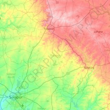
Name: Tuljapur topographic map, elevation, terrain.
Location: Tuljapur, Osmanabad, Maharashtra, India (17.65409 75.83698 18.09968 76.40575)
Average elevation: 546 m
Minimum elevation: 433 m
Maximum elevation: 711 m
Other topographic maps
Click on a map to view its topography, its elevation and its terrain.
Naldurg
India > Maharashtra > Tuljapur > Naldurg
Naldurg, Tuljapur, Osmanabad, Maharashtra, 413602, India
Average elevation: 561 m