
Caloocan topographic map
Interactive map
Click on the map to display elevation.
About this map
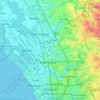
Name: Caloocan topographic map, elevation, terrain.
Location: Caloocan, Metro Manila, Philippines (14.63557 120.96064 14.78534 121.09912)
Average elevation: 22 m
Minimum elevation: -4 m
Maximum elevation: 98 m
South Caloocan, where most commercial and industrial establishments are found, lies on generally flat and highly accessible land, with slopes ranging from 0-3%. The topography gradually changes into gently to moderately sloping to rolling along the North Luzon Expressway, with slopes ranging from 3-18%. The highest point at 35.00 meters above sea level can be found in this area, while the lowest point is in the southern part of Dagat-Dagatan at about 0.993 meters above mean sea level.
Other topographic maps
Click on a map to view its topography, its elevation and its terrain.
Deparo
Deparo, Zone 15, Caybiga, District 1, Caloocan, Northern Manila District, Metro Manila, 1420, Philippines
Average elevation: 47 m
Barangay 162
Barangay 162, Caloocan, Metro Manila, 1402, Philippines
Average elevation: 23 m