
Nawala topographic map
Click on the map to display elevation.
About this map
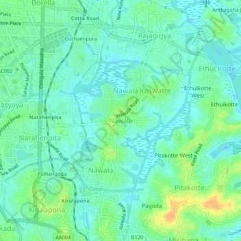
Name: Nawala topographic map, elevation, terrain.
Location: Nawala, Colombo District, Western Province, 10107, Sri Lanka (6.87521 79.87055 6.91521 79.91055)
Average elevation: 10 m
Minimum elevation: -1 m
Maximum elevation: 33 m
Other topographic maps
Click on a map to view its topography, its elevation and its terrain.
Wevita Lake
Sri Lanka > Western Province > Bandaragama DS Division > Bandaragama
Average elevation: 9 m
Uyanwatta Lake
Sri Lanka > Western Province > Bandaragama DS Division > Gelanigama
Average elevation: 16 m