
Oakland County topographic map
Interactive map
Click on the map to display elevation.
About this map
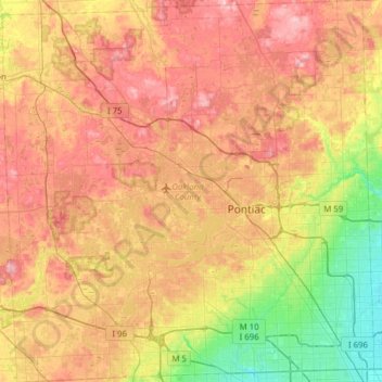
Name: Oakland County topographic map, elevation, terrain.
Location: Oakland County, Michigan, United States of America (42.43118 -83.68944 42.88865 -83.08338)
Average elevation: 282 m
Minimum elevation: 191 m
Maximum elevation: 382 m
Other topographic maps
Click on a map to view its topography, its elevation and its terrain.
Saint Clair County
United States of America > Michigan
Saint Clair County, Michigan, United States of America
Average elevation: 201 m
Antrim County
United States of America > Michigan
Antrim County, Michigan, United States of America
Average elevation: 276 m
Christmas
United States of America > Michigan > Christmas
Christmas, Au Train Township, Alger County, Michigan, United States of America
Average elevation: 203 m
Brooks Township
United States of America > Michigan
Brooks Township, Newaygo County, Michigan, 49337, United States of America
Average elevation: 237 m
Ontonagon County
United States of America > Michigan
Ontonagon County, Michigan, United States of America
Average elevation: 334 m
Mena Creek
United States of America > Michigan
Mena Creek, Lincoln Township, Newaygo County, Michigan, 40309, United States of America
Average elevation: 286 m
Sanilac County
United States of America > Michigan
Sanilac County, Michigan, United States of America
Average elevation: 228 m
Baraga County
United States of America > Michigan
Baraga County, Michigan, United States of America
Average elevation: 378 m