
Sewa topographic map
Interactive map
Click on the map to display elevation.
About this map
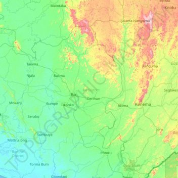
Name: Sewa topographic map, elevation, terrain.
Location: Sewa, Bo District, Southern Province, Sierra Leone (7.30751 -12.13816 8.69962 -11.25444)
Average elevation: 149 m
Minimum elevation: 0 m
Maximum elevation: 819 m
Other topographic maps
Click on a map to view its topography, its elevation and its terrain.
Sherbro Island
Sierra Leone > Southern Province
Sherbro Island, Bonthe District, Southern Province, Sierra Leone
Average elevation: 3 m
Selu
Sierra Leone > Southern Province > Selu
Selu, Bo District, Southern Province, Sierra Leone
Average elevation: 237 m
Bonthe
Sierra Leone > Southern Province > Bonthe
Bonthe, Bonthe District, Southern Province, Sierra Leone
Average elevation: 2 m