
Bremthal topographic map
Interactive map
Click on the map to display elevation.
About this map
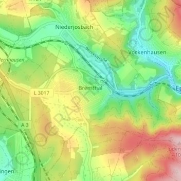
Name: Bremthal topographic map, elevation, terrain.
Location: Bremthal, Eppstein, Main-Taunus-Kreis, Hessen, Deutschland (50.12855 8.31765 50.15076 8.37885)
Average elevation: 280 m
Minimum elevation: 190 m
Maximum elevation: 404 m
Der höchste Punkt der Gemarkung liegt auf 350 m am Forstweg zum Judenkopf, etwa 800 Meter westlich der Gipfelhöhe (410 m). Südlich derselben befindet sich ein Wasserbehälter, der Bremthal und Lorsbach mit Wasser versorgt.
Other topographic maps
Click on a map to view its topography, its elevation and its terrain.
Vockenhausen
Deutschland > Hessen > Main-Taunus-Kreis > Eppstein
Vockenhausen, Eppstein, Main-Taunus-Kreis, Hessen, Deutschland
Average elevation: 275 m