
Zakarpattia Oblast topographic map
Interactive map
Click on the map to display elevation.
About this map
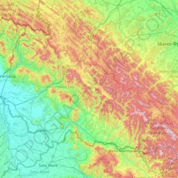
Name: Zakarpattia Oblast topographic map, elevation, terrain.
Location: Zakarpattia Oblast, Ukraine (47.89747 22.13706 49.09732 24.62747)
Average elevation: 548 m
Minimum elevation: 101 m
Maximum elevation: 1,978 m
The region's climate is moderate and continental with about 700–1,000 mm (28–39 in) of rainfall per year. The average temperature in summer is +21 °С (70 °F) and −4 °С (25 °F) in winter. With an elevation of 2,061 metres (6,762 ft) above sea level, Hoverla, part of the Chornohora mountain range, is the highest point in the oblast. The lowest point, 101 m (331 ft) above sea level, is located in the village of Ruski Heyevtsi (Oroszgejőc in Hungarian) in the Uzhhorodskyi Raion.
Other topographic maps
Click on a map to view its topography, its elevation and its terrain.
Berehove
Berehove, Berehove Urban Hromada, Berehove Raion, Zakarpattia Oblast, Ukraine
Average elevation: 131 m
Hoverla
Hoverla, Rakhiv Raion, Zakarpattia Oblast, Ukraine
Average elevation: 1,667 m
Solotvyno
Ukraine > Zakarpattia Oblast > Solotvyno > Solotvyno
Solotvyno, Tiachiv Raion, Zakarpattia Oblast, 90575, Ukraine
Average elevation: 293 m