
Fairfield County topographic map
Interactive map
Click on the map to display elevation.
About this map
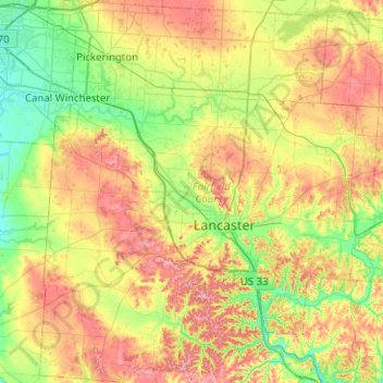
Name: Fairfield County topographic map, elevation, terrain.
Location: Fairfield County, Ohio, United States of America (39.55440 -82.84294 39.94106 -82.36606)
Average elevation: 282 m
Minimum elevation: 220 m
Maximum elevation: 375 m
Other topographic maps
Click on a map to view its topography, its elevation and its terrain.
Pottersburg
United States of America > Ohio > Pottersburg
Pottersburg, Allen Township, Union County, Ohio, United States of America
Average elevation: 331 m
Greenhills
United States of America > Ohio > Greenhills > Greenhills
Greenhills, Hamilton County, Ohio, United States of America
Average elevation: 238 m