
Łyna/Лава topographic map
Interactive map
Click on the map to display elevation.
About this map
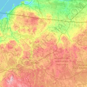
Name: Łyna/Лава topographic map, elevation, terrain.
Average elevation: 102 m
Minimum elevation: -5 m
Maximum elevation: 304 m
Other topographic maps
Click on a map to view its topography, its elevation and its terrain.
Marązy
Poland > Warmian-Masurian Voivodeship > Olsztyn County
Marązy, gmina Olsztynek, Olsztyn County, Warmian-Masurian Voivodeship, Poland
Average elevation: 159 m
Dziubiele
Poland > Warmian-Masurian Voivodeship > Dziubiele
Dziubiele, gmina Orzysz, powiat piski, Warmian-Masurian Voivodeship, 12-250, Poland
Average elevation: 122 m
Przystań
Poland > Warmian-Masurian Voivodeship > Przystań
Przystań, gmina Węgorzewo, powiat węgorzewski, Warmian-Masurian Voivodeship, 11-600, Poland
Average elevation: 121 m
Duba
Poland > Warmian-Masurian Voivodeship > Duba
Duba, gmina Zalewo, powiat iławski, Warmian-Masurian Voivodeship, Poland
Average elevation: 112 m