
Mediodía-Pirineos topographic map
Interactive map
Click on the map to display elevation.
About this map
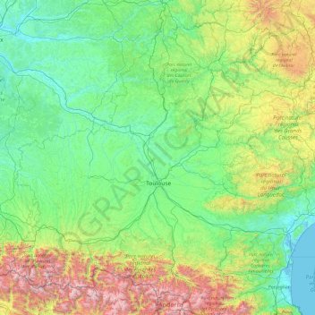
Name: Mediodía-Pirineos topographic map, elevation, terrain.
Average elevation: 508 m
Minimum elevation: -2 m
Maximum elevation: 3,311 m
Other topographic maps
Click on a map to view its topography, its elevation and its terrain.
Languedoc-Rosellón
Languedoc-Rosellón, D 85, Les Mathalis, Rivel, Limoux, Aude, Occitania, Francia metropolitana, 11230, Francia
Average elevation: 384 m