
Spearhead Glacier topographic map
Interactive map
Click on the map to display elevation.
About this map
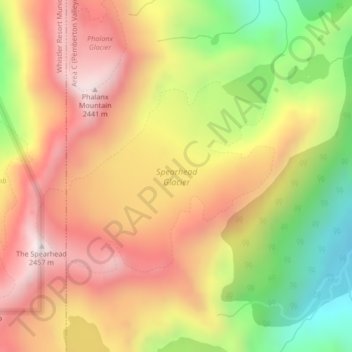
Name: Spearhead Glacier topographic map, elevation, terrain.
Average elevation: 2,082 m
Minimum elevation: 1,644 m
Maximum elevation: 2,434 m
Other topographic maps
Click on a map to view its topography, its elevation and its terrain.
Decker Glacier
Canada > British Columbia > Whistler Resort Municipality
Decker Glacier, Overlord Trail, Whistler Resort Municipality, Squamish-Lillooet Regional District, British Columbia, Canada
Average elevation: 2,130 m