
Hood River County topographic map
Interactive map
Click on the map to display elevation.
About this map
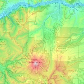
Name: Hood River County topographic map, elevation, terrain.
Location: Hood River County, Oregon, United States (45.25773 -121.92227 45.72651 -121.44058)
Average elevation: 860 m
Minimum elevation: 2 m
Maximum elevation: 3,388 m
Hood River County is 533 square miles (1,380 km2), of which 522 square miles (1,350 km2) is land and 11 square miles (28 km2) (2.1%) is water. It is the second-smallest county in Oregon by area. Elevation ranges from 60 feet (18 m) above sea level at Cascade Locks in the northwest to 11,235 feet (3,424 m) at the summit of Mt. Hood, the highest point in Oregon.
Other topographic maps
Click on a map to view its topography, its elevation and its terrain.
Mulino
United States > Oregon > Clackamas County
Mulino, Clackamas County, Oregon, 97042, United States
Average elevation: 100 m
Madras
United States > Oregon > Jefferson County
Madras, Jefferson County, Oregon, United States
Average elevation: 739 m
Coos Bay
United States > Oregon > Coos County
Coos Bay, Coos County, Oregon, 97420, United States
Average elevation: 30 m
Rainbow
United States > Oregon > Lane County
Rainbow, Lane County, Oregon, 97413, United States
Average elevation: 486 m
Eugene
United States > Oregon > Lane County
Eugene, Lane County, Oregon, United States
Average elevation: 163 m
Chiloquin
United States > Oregon > Klamath County
Chiloquin, Klamath County, Oregon, United States
Average elevation: 1,302 m
Corvallis
United States > Oregon > Benton County
Corvallis, Benton County, Oregon, United States
Average elevation: 81 m
Medford
United States > Oregon > Jackson County > Medford
Medford, Jackson County, Oregon, United States
Average elevation: 441 m
Lakeside
United States > Oregon > Coos County > Lakeside
Lakeside, Coos County, Oregon, United States
Average elevation: 32 m
Lakeview
United States > Oregon > Lake County
Lakeview, Lake County, Oregon, 97630, United States
Average elevation: 1,562 m
Multnomah County
Multnomah County, Oregon, United States
Average elevation: 334 m
Deschutes County
Deschutes County, Oregon, United States
Average elevation: 1,324 m
Salem
United States > Oregon > Marion County
Salem, Marion County, Oregon, United States
Average elevation: 96 m