
Kapit topographic map
Interactive map
Click on the map to display elevation.
About this map
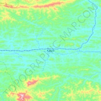
Name: Kapit topographic map, elevation, terrain.
Location: Kapit, Sarawak, 96800, Malaysia (1.85390 112.77568 2.17390 113.09568)
Average elevation: 175 m
Minimum elevation: 6 m
Maximum elevation: 992 m
Other topographic maps
Click on a map to view its topography, its elevation and its terrain.
Kapit Division
Kapit Division, Kapit, Sarawak, 96800, Malaysia
Average elevation: 56 m