
Ob River topographic map
Interactive map
Click on the map to display elevation.
About this map
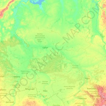
Name: Ob River topographic map, elevation, terrain.
Location: Ob River, Ural Federal District, 628179, Russia (52.30043 65.04695 66.78650 84.97333)
Average elevation: 122 m
Minimum elevation: -1 m
Maximum elevation: 2,033 m
The combined Ob-Irtysh system, the fourth-longest river system of Asia (after Yenisei, and China's Yangzi and Yellow rivers), is 5,410 kilometres (3,360 mi) long, and the area of its basin 2,990,000 square kilometres (1,150,000 sq mi). The river basin of the Ob consists mostly of steppe, taiga, swamps, tundra, and semi-desert topography. The floodplains of the Ob are characterized by many tributaries and lakes. The Ob is ice-bound at southern Barnaul from early in November to near the end of April, and at northern Salekhard, 150 km (93 mi) above its mouth, from the end of October to the beginning of June. The Ob River crosses several climatic zones. The upper Ob valley, in the south, grows grapes, melons and watermelons, whereas the lower reaches of the Ob are Arctic tundra. The most comfortable climate for the rest on the Ob are Biysk, Barnaul, and Novosibirsk.
Other topographic maps
Click on a map to view its topography, its elevation and its terrain.
Khanty-Mansiysk Urban Okrug
Russia > Khanty-Mansiysk Autonomous Okrug – Ugra > Khanty-Mansiysk Urban Okrug
Khanty-Mansiysk Urban Okrug, Khanty-Mansiysk Autonomous Okrug – Ugra, Ural Federal District, Russia
Average elevation: 28 m
Surgut
Russia > Khanty-Mansiysk Autonomous Okrug – Ugra > Surgut
Surgut, Khanty-Mansiysk Autonomous Okrug – Ugra, Ural Federal District, Russia
Average elevation: 49 m
Лаут
Russia > Khanty-Mansiysk Autonomous Okrug – Ugra
Лаут, Kondinsky District, Khanty-Mansiysk Autonomous Okrug – Ugra, Ural Federal District, Russia
Average elevation: 52 m
Ural Mountains
Russia > Khanty-Mansiysk Autonomous Okrug – Ugra
Ural Mountains, Beryozovsky District, Khanty-Mansiysk Autonomous Okrug – Ugra, Ural Federal District, Russia
Average elevation: 1,435 m
Лаут
Russia > Khanty-Mansiysk Autonomous Okrug – Ugra
Лаут, Kondinsky District, Khanty-Mansiysk Autonomous Okrug – Ugra, Ural Federal District, Russia
Average elevation: 63 m