
Innsbruck topographic map
Interactive map
Click on the map to display elevation.
About this map
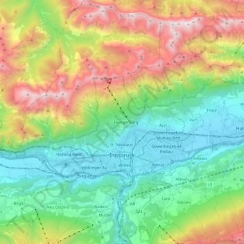
Name: Innsbruck topographic map, elevation, terrain.
Location: Innsbruck, Tyrol, Austria (47.21077 11.30164 47.36013 11.45596)
Average elevation: 1,280 m
Minimum elevation: 558 m
Maximum elevation: 2,668 m
Other topographic maps
Click on a map to view its topography, its elevation and its terrain.
Sankt Anton am Arlberg
Austria > Tyrol > Sankt Anton am Arlberg
Sankt Anton am Arlberg, Landeck, Tyrol, 6580, Austria
Average elevation: 2,134 m
Stadt Wörgl
Austria > Tyrol > Stadt Wörgl
Stadt Wörgl, Bezirk Kufstein, Tyrol, 6300, Austria
Average elevation: 740 m
Gemeinde Obertilliach
Austria > Tyrol > Gemeinde Obertilliach
Gemeinde Obertilliach, Bezirk Lienz, Tyrol, 9942, Austria
Average elevation: 1,853 m
St. Johann in Tirol
Austria > Tyrol > St. Johann in Tirol
St. Johann in Tirol, Kitzbühel, Tyrol, 6380, Austria
Average elevation: 982 m
Wildspitze
Wildspitze, Sölden, Imst, Tyrol, 6458, Austria
Average elevation: 3,284 m
Tux Alps
Austria > Tyrol > Wattenberg
Tux Alps, Wattenberg, Innsbruck-Land, Tyrol, Austria
Average elevation: 1,555 m
Ötztal Alps
Ötztal Alps, Vernagthütte Guslarspitzen, Sölden, Imst, Tyrol, 6458, Austria
Average elevation: 2,098 m
Lechtal Alps
Lechtal Alps, Pfafflar, Reutte (Außerfern), Tyrol, Austria
Average elevation: 1,616 m