
Bilaspur topographic map
Interactive map
Click on the map to display elevation.
About this map
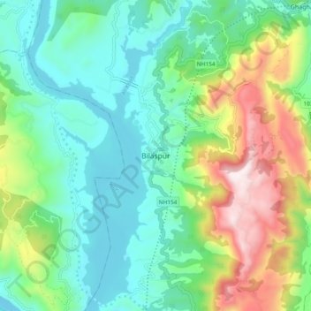
Name: Bilaspur topographic map, elevation, terrain.
Location: Bilaspur, Himachal Pradesh, 174001, India (31.29810 76.72116 31.37810 76.80116)
Average elevation: 738 m
Minimum elevation: 472 m
Maximum elevation: 1,382 m
Other topographic maps
Click on a map to view its topography, its elevation and its terrain.
Berthin
India > Himachal Pradesh > Bilaspur
Berthin, Bilaspur, Himachal Pradesh, 174029, India
Average elevation: 621 m
Ghumarwin
India > Himachal Pradesh > Bilaspur
Ghumarwin, Bilaspur, Himachal Pradesh, India
Average elevation: 774 m
Naina Devi
India > Himachal Pradesh > Bilaspur
Naina Devi, Bilaspur, Himachal Pradesh, India
Average elevation: 490 m