
Pushparajgarh Tehsil topographic map
Interactive map
Click on the map to display elevation.
About this map
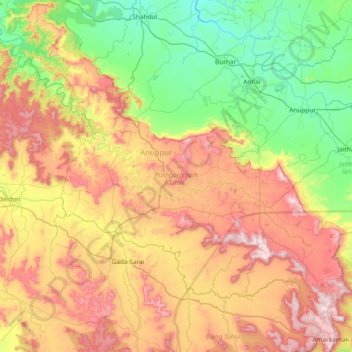
Name: Pushparajgarh Tehsil topographic map, elevation, terrain.
Location: Pushparajgarh Tehsil, Anuppur, Madhya Pradesh, India (22.64540 81.12401 23.33130 81.79315)
Average elevation: 710 m
Minimum elevation: 418 m
Maximum elevation: 1,160 m
Other topographic maps
Click on a map to view its topography, its elevation and its terrain.
Garjanbija
India > Madhya Pradesh > Pushparajgarh Tehsil
Garjanbija, Pushparajgarh Tehsil, Anuppur District, Madhya Pradesh, India
Average elevation: 940 m
Amarkantak
India > Madhya Pradesh > Pushparajgarh Tehsil > Amarkantak
Amarkantak, Pushparajgarh Tehsil, Anuppur, Madhya Pradesh, 484886, India
Average elevation: 884 m