
Karukachal topographic map
Interactive map
Click on the map to display elevation.
About this map
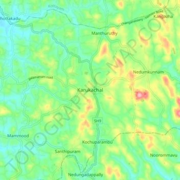
Name: Karukachal topographic map, elevation, terrain.
Location: Karukachal, Changanassery, Kottayam, Kerala, 686540, India (9.46116 76.59836 9.54116 76.67836)
Average elevation: 49 m
Minimum elevation: 3 m
Maximum elevation: 144 m
Other topographic maps
Click on a map to view its topography, its elevation and its terrain.
Koothrapally Pond,koothrapally
India > Kerala > Changanassery > Karukachal
Koothrapally Pond,koothrapally, Karukachal, Changanassery, Kottayam, Kerala, India
Average elevation: 54 m