
Paschim Bardhaman topographic map
Interactive map
Click on the map to display elevation.
About this map
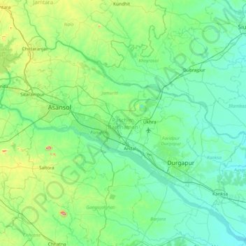
Name: Paschim Bardhaman topographic map, elevation, terrain.
Location: Paschim Bardhaman, West Bengal, India (23.40361 86.79886 23.88293 87.53550)
Average elevation: 105 m
Minimum elevation: 44 m
Maximum elevation: 431 m
The rocky undulating topography with laterite soil found in Paschim Bardhaman district is a sort of extension of the Chota Nagpur plateau. For ages the area was heavily forested and infested with plunderers and marauders. The discovery of coal in the 18th century led to industrialisation. Most of the forests in the coal-bearing areas have been cleared but some areas in the eastern part of the district remained thickly forested till more recent times and some are still there. The eastern part of the district gradually slopes down to the rice plains of the agriculturally rich Purba Bardhaman district.
Other topographic maps
Click on a map to view its topography, its elevation and its terrain.
Siliguri
India > West Bengal > Siliguri Subdivsion
Siliguri, Siliguri Subdivsion, Darjeeling District, West Bengal, India
Average elevation: 121 m
Bangaon
India > West Bengal > Bongaon
Bangaon, Bongaon, North 24 Parganas District, West Bengal, 743235, India
Average elevation: 7 m
Darjeeling district
Darjeeling district, West Bengal, India
Average elevation: 728 m
Taki
India > West Bengal > Hasnabad
Taki, Hasnabad, North 24 Parganas District, West Bengal, 743429, India
Average elevation: 4 m
Thakurpukur Maheshtala
Thakurpukur Maheshtala, South 24 Parganas District, West Bengal, India
Average elevation: 5 m
Rajganj
India > West Bengal > Rajganj
Rajganj, Jalpaiguri District, West Bengal, 735134, India
Average elevation: 93 m
Swabhumi
India > West Bengal > Kolkata
Swabhumi, Kolkata, Kolkata District, West Bengal, India
Average elevation: 6 m
Kolkata
Kolkata, Kolkata District, West Bengal, 700073, India
Average elevation: 5 m
Mathurapur - I
Mathurapur - I, South 24 Parganas District, West Bengal, 743354, India
Average elevation: 4 m
Bidhannagar
Bidhannagar, North 24 Parganas District, West Bengal, India
Average elevation: 5 m
Bhangar - I
Bhangar - I, South 24 Parganas District, West Bengal, 743502, India
Average elevation: 3 m
Bolpur
India > West Bengal > Bolpur Sriniketan
Bolpur, Bolpur Sriniketan, Birbhum District, West Bengal, India
Average elevation: 50 m
West Dinājpur
West Dinājpur, Dakshin Dinajpur District, West Bengal, India
Average elevation: 34 m
Medinipur
India > West Bengal > Midnapore
Medinipur, Midnapore, Paschim Medinipur District, West Bengal, 721101, India
Average elevation: 39 m
Rampurhat
India > West Bengal > Rampurhat - I
Rampurhat, Rampurhat - I, Birbhum District, West Bengal, 731224, India
Average elevation: 38 m
Gangapur
India > West Bengal > Barasat - I
Gangapur, Barasat - I, North 24 Parganas District, West Bengal, 743248, India
Average elevation: 7 m
Baranagar
India > West Bengal > Barrackpore
Baranagar, Barrackpore, North 24 Parganas District, West Bengal, 700035, India
Average elevation: 6 m
Asansol Kulti Township
Asansol Kulti Township, Paschim Bardhaman District, West Bengal, India
Average elevation: 125 m
Kolkata
Kolkata, Kolkata District, West Bengal, India, Adi Ganga
Average elevation: 8 m
Raiganj
Raiganj, Uttar Dinajpur District, West Bengal, India
Average elevation: 35 m
B-13
India > West Bengal > Kalyani
B-13, Kalyani, Nadia District, West Bengal, India
Average elevation: 10 m
Kharagpur
India > West Bengal > Kharagpur-I
Kharagpur, Kharagpur-I, Paschim Medinipur District, West Bengal, 721301, India
Average elevation: 39 m
North Dumdum
India > West Bengal > Barrackpore
North Dumdum, Barrackpore, North 24 Parganas District, West Bengal, 700051, India
Average elevation: 7 m
Garbeta-III
Garbeta-III, Paschim Medinipur District, West Bengal, 721253, India
Average elevation: 42 m
Kangsabati Reservoir
India > West Bengal > Ranibundh
Kangsabati Reservoir, Ranibundh, Bankura District, West Bengal, India
Average elevation: 136 m
Ghatal
Ghatal, Paschim Medinipur District, West Bengal, India
Average elevation: 11 m
Malda
India > West Bengal > English Bazar
Malda, English Bazar, Maldah, West Bengal, 732101, India
Average elevation: 26 m
Tufanganj - I
Tufanganj - I, Cooch Behar District, West Bengal, India
Average elevation: 37 m
Dum Dum
India > West Bengal > Barrackpore
Dum Dum, Barrackpore, North 24 Parganas District, West Bengal, 700081, India
Average elevation: 6 m
Darjeeling Pulbazar
Darjeeling Pulbazar, Darjeeling District, West Bengal, India
Average elevation: 1,779 m
Chandipur
Chandipur, Purba Medinipur District, West Bengal, 721659, India
Average elevation: 4 m
Shiulibari
India > West Bengal > Contai-III
Shiulibari, Contai-III, Purba Medinipur District, West Bengal, 721449, India
Average elevation: 4 m
Digha
India > West Bengal > Digha
Digha, Ramnagar-I, Purba Medinipur, West Bengal, 721428, India
Average elevation: 4 m
Bikna
India > West Bengal > Bankura - II
Bikna, Bankura - II, Bankura District, West Bengal, 722180, India
Average elevation: 85 m
Bishnupur - II
Bishnupur - II, South 24 Parganas District, West Bengal, 743377, India
Average elevation: 4 m
Diamond Harbour - II
Diamond Harbour - II, South 24 Parganas, West Bengal, 743368, India
Average elevation: 3 m
Bhangar - II
Bhangar - II, South 24 Parganas, West Bengal, India
Average elevation: 4 m
Krishnanagar
India > West Bengal > Krishnagar-I > Krishnanagar
Krishnanagar, Krishnagar-I, Nadia, West Bengal, 741101, India
Average elevation: 11 m
Sevoke
India > West Bengal > Sevoke
Sevoke, Darjiling, Darjeeling, West Bengal, India
Average elevation: 254 m
Cooch Behar
India > West Bengal > Cooch Behar
Cooch Behar, Koch Bihār, Kochbihar, West Bengal, 736101, India
Average elevation: 43 m
Sagar Island
Sagar Island, Sagar, South 24 Parganas, West Bengal, 743606, India
Average elevation: 2 m