
Unokoti topographic map
Interactive map
Click on the map to display elevation.
About this map
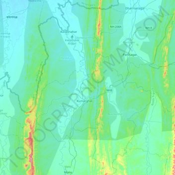
Name: Unokoti topographic map, elevation, terrain.
Location: Unokoti, Tripura, India (23.99051 91.90787 24.39156 92.20439)
Average elevation: 70 m
Minimum elevation: 17 m
Maximum elevation: 430 m
The topographic features seem to have influenced the climatic condition of the Unakoti district, where the plains are hotter and humid in comparison to the hills, which have a salubrious climate. The four main seasons here are
Other topographic maps
Click on a map to view its topography, its elevation and its terrain.
Haora River
Haora River, Agartala, West Tripura, Tripura, 799001, India
Average elevation: 18 m
Kailashahar
India > Tripura > Gournagar > Kailashahar
Kailashahar, Gournagar, Unokoti, Tripura, 799277, India
Average elevation: 33 m
South Tripura
India > Tripura > South Tripura
South Tripura, Gomati, Tripura, India
Average elevation: 75 m