
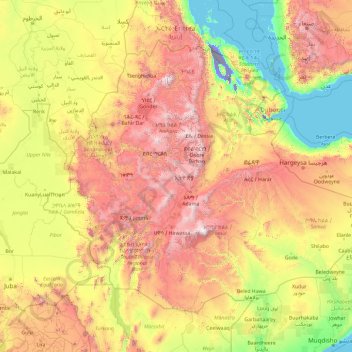
Äthiopien topographic map
Interactive map
Click on the map to display elevation.
About this map
Name: Äthiopien topographic map, elevation, terrain.
Location: Äthiopien (3.39745 32.99758 14.89434 47.98238)
Average elevation: 846 m
Minimum elevation: -123 m
Maximum elevation: 4,296 m
Die Landesnatur Äthiopiens nimmt innerhalb Afrikas eine Sonderrolle ein. Äthiopien ist neben Lesotho das am höchsten gelegene Land des Kontinents: 50 Prozent seiner Fläche liegen höher als 1200 Meter, mehr als 25 Prozent über 1800 Meter, mehr als 5 Prozent erreichen sogar Höhen über 3500 Meter. Dennoch hat der größte Teil des Hochlandes Mittelgebirgscharakter. Hier herrscht gemäßigtes Klima vor. Die Hochlandränder und die Einschnitte der Flüsse (Blauer Nil, Omo, Tekeze) sind sehr steil.
Other topographic maps
Click on a map to view its topography, its elevation and its terrain.
India
India
Average elevation: 1,017 m
Montreal
Canada > Quebec > Urban agglomeration of Montreal > Montreal
Montreal, Urban agglomeration of Montreal, Montreal (06), Quebec, H3B 1M7, Canada
Average elevation: 30 m
Sri Lanka
Sri Lanka
Average elevation: 50 m
Hyderabad
India > Telangana > Bahadurpura mandal
Hyderabad, Bahadurpura mandal, Hyderabad District, Telangana, India
Average elevation: 549 m
Sirpur
India > Chhattisgarh > Mahasamund Tahsil
Sirpur, Mahasamund Tahsil, Mahasamund District, Chhattisgarh, India
Average elevation: 255 m
Thanjavur
India > Tamil Nadu > Thanjavur
Thanjavur, Thanjavur District, Tamil Nadu, 613001, India
Average elevation: 49 m
Sagwara
India > Rajasthan > Sagwara Tehsil
Sagwara, Sagwara Tehsil, Dungarpur District, Rajasthan, 314025, India
Average elevation: 177 m
Tacoma
United States > Washington > Pierce County
Tacoma, Pierce County, Washington, United States
Average elevation: 67 m
Pune
India > Maharashtra > Pune City > Pune
Pune, Pune City, Pune District, Maharashtra, 411001, India
Average elevation: 641 m
Bengaluru
India > Karnataka > Bangalore North
Bengaluru, Bangalore North, Bengaluru Urban, Karnataka, India
Average elevation: 886 m
Sabla
India > Rajasthan > Sabla Tehsil
Sabla, Sabla Tehsil, Dungarpur District, Rajasthan, 314022, India
Average elevation: 177 m
Kanyakumari district
Kanyakumari district, Tamil Nadu, India
Average elevation: 226 m
Bhemai
India > Rajasthan > Galiakot Tehsil
Bhemai, Galiakot Tehsil, Dungarpur District, Rajasthan, India
Average elevation: 187 m
Bhatwari
Bhatwari, Uttarkashi District, Uttarakhand, India
Average elevation: 4,570 m
Musi River
Musi River, Hyderabad, Uppal mandal, Medchal–Malkajgiri, Telangana, 5000036, India
Average elevation: 490 m
Snohomish County
Snohomish County, Washington, United States
Average elevation: 649 m
Madurai
India > Tamil Nadu > Madurai
Madurai, Madurai South, Madurai district, Tamil Nadu, India
Average elevation: 138 m
Aspur
India > Rajasthan > Aspur Tehsil
Aspur, Aspur Tehsil, Dungarpur District, Rajasthan, 314021, India
Average elevation: 223 m
Gowari
India > Rajasthan > Sagwara Tehsil
Gowari, Sagwara Tehsil, Dungarpur District, Rajasthan, India
Average elevation: 178 m
Kariyana
India > Rajasthan > Sagwara Tehsil
Kariyana, Sagwara Tehsil, Dungarpur District, Rajasthan, 314032, India
Average elevation: 167 m
Jhonthri
India > Rajasthan > Jhonthtri Tehsil
Jhonthri, Jhonthtri Tehsil, Dungarpur District, Rajasthan, 314404, India
Average elevation: 284 m
Sirpur
India > Madhya Pradesh > Khalwa Tahsil
Sirpur, Khalwa Tahsil, Khandwa District, Madhya Pradesh, India
Average elevation: 313 m
Mandi
India > Himachal Pradesh > Mandi
Mandi, Mandi District, Himachal Pradesh, 175001, India
Average elevation: 1,273 m
Chennai
India > Tamil Nadu > Chennai
Chennai, Chennai District, Tamil Nadu, India
Average elevation: 8 m
Mangaluru
India > Karnataka > Mangaluru taluk
Mangaluru, Mangaluru taluk, Dakshina Kannada District, Karnataka, 575001, India
Average elevation: 25 m
Vadodara
India > Gujarat > Vadodara Taluka
Vadodara, Vadodara Taluka, Vadodara District, Gujarat, 390001, India
Average elevation: 36 m
Nepal
Nepal
Average elevation: 2,604 m
Borigama Chhota
India > Rajasthan > Sabla Tehsil
Borigama Chhota, Sabla Tehsil, Dungarpur District, Rajasthan, India
Average elevation: 169 m
Nadiya
India > Rajasthan > Galiakot Tehsil
Nadiya, Galiakot Tehsil, Dungarpur District, Rajasthan, India
Average elevation: 148 m
Bormali
India > Rajasthan > Simalwara Tehsil
Bormali, Simalwara Tehsil, Dungarpur District, Rajasthan, India
Average elevation: 227 m
Peeth
India > Rajasthan > Simalwara Tehsil
Peeth, Simalwara Tehsil, Dungarpur District, Rajasthan, 314406, India
Average elevation: 219 m
Silohi
India > Rajasthan > Galiakot Tehsil
Silohi, Galiakot Tehsil, Dungarpur District, Rajasthan, 314026, India
Average elevation: 140 m
Anaikatti
India > Tamil Nadu > Coimbatore North
Anaikatti, Mannarkad, Palakkad District, Kerala, 678741, India
Average elevation: 623 m
Surat
India > Gujarat > Katargam Taluka > Surat
Surat, Katargam Taluka, Surat, Gujarat, 395001, India
Average elevation: 11 m
Kampur
India > Madhya Pradesh > Raisen Tahsil
Kampur, Raisen Tahsil, Raisen District, Madhya Pradesh, India
Average elevation: 462 m
Radisson
Canada > Saskatchewan > Division No. 16
Radisson, Division No. 16, Saskatchewan, S0K 3L0, Canada
Average elevation: 523 m
Stuvsta-Snättringe
Stuvsta-Snättringe, Huddinge kommun, Stockholm County, 141 43, Sweden
Average elevation: 41 m
Gladwyne
United States > Pennsylvania > Montgomery County > Lower Merion Township
Gladwyne, Lower Merion Township, Montgomery County, Pennsylvania, 19035, United States
Average elevation: 92 m