
Arendsee topographic map
Interactive map
Click on the map to display elevation.
About this map
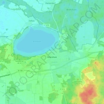
Name: Arendsee topographic map, elevation, terrain.
Average elevation: 32 m
Minimum elevation: 19 m
Maximum elevation: 71 m
Other topographic maps
Click on a map to view its topography, its elevation and its terrain.
Kleinau
Deutschland > Sachsen-Anhalt > Arendsee (Altmark) > Kleinau
Kleinau, Arendsee (Altmark), Altmarkkreis Salzwedel, Sachsen-Anhalt, Deutschland
Average elevation: 33 m
Schrampe
Deutschland > Sachsen-Anhalt > Arendsee (Altmark) > Schrampe
Schrampe, Arendsee (Altmark), Altmarkkreis Salzwedel, Sachsen-Anhalt, Deutschland
Average elevation: 26 m