
Arnstadt topographic map
Interactive map
Click on the map to display elevation.
About this map
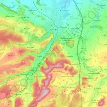
Name: Arnstadt topographic map, elevation, terrain.
Location: Arnstadt, Ilm-Kreis, Thüringen, 99310, Deutschland (50.72676 10.87006 50.87564 11.05314)
Average elevation: 383 m
Minimum elevation: 242 m
Maximum elevation: 603 m
Other topographic maps
Click on a map to view its topography, its elevation and its terrain.
Götzberg
Deutschland > Thüringen > Arnstadt
Götzberg, Arnstadt, Ilm-Kreis, Thüringen, 99338, Deutschland
Average elevation: 382 m