
Chihuahua topographic map
Interactive map
Click on the map to display elevation.
About this map
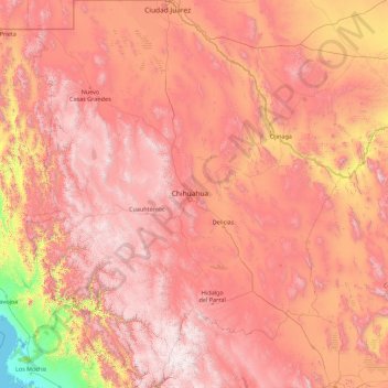
Name: Chihuahua topographic map, elevation, terrain.
Location: Chihuahua, Mexico (25.55866 -109.07498 31.78390 -103.30669)
Average elevation: 1,397 m
Minimum elevation: -1 m
Maximum elevation: 3,119 m
The main mountain range in the state is the Sierra Madre Occidental reaching a maximum altitude of 10,826 ft (3,300 m) known as Cerro Mohinora. Mountains account for one third of the state's surface area which include large coniferous forests. The climate in the mountainous regions varies. Chihuahua has more forests than any other state in Mexico making the area a bountiful source of wood; the mountainous areas are rich in minerals important to Mexico's mining industry. Precipitation and temperature in the mountainous areas depends on the elevation. Between the months of November and March snow storms are possible in the lower elevations and are frequent in the higher elevations. There are several watersheds located in the Sierra Madre Occidental all of the water that flows through the state; most of the rivers finally empty into the Río Grande. Temperatures in some canyons in the state reach over 100 °F (38 °C) in the summer while the same areas rarely drop below 32 °F (0 °C) in the winter. Microclimates found in the heart of the Sierra Madre Occidental in the state could be considered tropical, and wild tropical plants have been found in some canyons. La Barranca del Cobre, or Copper Canyon, a spectacular canyon system larger and deeper than the Grand Canyon; the canyon also contains Mexico's two tallest waterfalls: Basaseachic Falls and Piedra Volada. There are two national parks found in the mountainous area of the state: Cumbres de Majalca National Park and Basaseachic Falls National Park.
Other topographic maps
Click on a map to view its topography, its elevation and its terrain.
Chetumal
Mexico > Quintana Roo > Othón P. Blanco
Chetumal, Othón P. Blanco, Quintana Roo, Mexico
Average elevation: 5 m
Tijuana
Mexico > Baja California > Municipio de Tijuana
Tijuana, Municipio de Tijuana, Baja California, 22320, Mexico
Average elevation: 141 m
Playa del Carmen
Playa del Carmen, Solidaridad, Quintana Roo, Mexico
Average elevation: 5 m
Volcán Mazatepec
Mexico > Nayarit > Compostela
Volcán Mazatepec, Compostela, Nayarit, 63716, Mexico
Average elevation: 768 m
Volcán Chichinautzin
Volcán Chichinautzin, Mexico City, 14904, Mexico
Average elevation: 3,240 m
Jacona de Plancarte
Jacona de Plancarte, Jacona, Michoacán, 59893, Mexico
Average elevation: 1,631 m
San Francisco Tutla
Mexico > Oaxaca > Santa Lucía del Camino
San Francisco Tutla, Santa Lucía del Camino, Oaxaca, 71320, Mexico
Average elevation: 1,627 m
COL. MADERAS
Mexico > Campeche > Carmen > Ciudad del Carmen
COL. MADERAS, Ciudad del Carmen, Carmen, Campeche, 24100, Mexico
Average elevation: 2 m
Gustavo A. Madero
Gustavo A. Madero, Mexico City, Mexico
Average elevation: 2,301 m
San Guillermo
Mexico > Chihuahua > Aquiles Serdán
San Guillermo, Aquiles Serdán, Chihuahua, Mexico
Average elevation: 1,549 m
Texcoco de Mora
Mexico > State of Mexico > Texcoco
Texcoco de Mora, Texcoco, State of Mexico, 56100, Mexico
Average elevation: 2,262 m
Yahualica de González Gallo
Yahualica de González Gallo, Jalisco, Mexico
Average elevation: 1,883 m
Los Cabos Municipality
Los Cabos Municipality, Baja California Sur, Mexico
Average elevation: 278 m
Chihuahua
Mexico > Chihuahua > Municipio de Chihuahua
Chihuahua, Municipio de Chihuahua, Chihuahua, 31100, Mexico
Average elevation: 1,555 m
Rincón de Romos
Mexico > Aguascalientes > Rincón de Romos
Rincón de Romos, Aguascalientes, 20603, Mexico
Average elevation: 1,981 m
Pabellón de Arteaga
Pabellón de Arteaga, Aguascalientes, Mexico
Average elevation: 1,984 m
Municipio de Mexicali
Municipio de Mexicali, Baja California, Mexico
Average elevation: 214 m
Municipio de Loreto
Municipio de Loreto, Baja California Sur, Mexico
Average elevation: 171 m
Municipio de Tijuana
Municipio de Tijuana, Baja California, Mexico
Average elevation: 369 m