
Chile topographic map
Interactive map
Click on the map to display elevation.
About this map
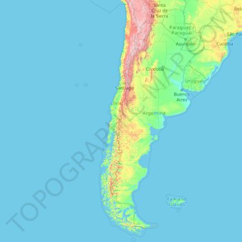
Name: Chile topographic map, elevation, terrain.
Location: Chile (-56.72500 -109.67958 -17.49838 -66.07535)
Average elevation: 193 m
Minimum elevation: -1 m
Maximum elevation: 6,259 m
The Far North is the area between the northern boundary of the country and the parallel 26° S, covering the first three regions. It is characterized by the presence of the Atacama desert, the most arid in the world. The desert is fragmented by streams that originate in the area known as the pampas Tamarugal. The Andes, split in two and whose eastern arm runs through Bolivia, has a high altitude and volcanic activity, which has allowed the formation of the Andean altiplano and salt structures as the Salar de Atacama, due to the gradual accumulation of sediments over time.
Other topographic maps
Click on a map to view its topography, its elevation and its terrain.
Hyderabad
India > Telangana > Bahadurpura mandal
Hyderabad, Bahadurpura mandal, Hyderabad District, Telangana, India
Average elevation: 549 m
Sri Lanka
Sri Lanka
Average elevation: 50 m
India
India
Average elevation: 1,017 m
Montreal
Canada > Quebec > Urban agglomeration of Montreal > Montreal
Montreal, Urban agglomeration of Montreal, Montreal (06), Quebec, H3B 1M7, Canada
Average elevation: 30 m
Navi Mumbai
India > Maharashtra > Thane > Navi Mumbai
Navi Mumbai, Mumbai Metropolitan Region, Thane, Maharashtra, 400706, India
Average elevation: 30 m
Pune
India > Maharashtra > Pune City > Pune
Pune, Pune City, Pune District, Maharashtra, 411001, India
Average elevation: 641 m
Tacoma
United States > Washington > Pierce County
Tacoma, Pierce County, Washington, United States
Average elevation: 67 m
Bengaluru
India > Karnataka > Bangalore North
Bengaluru, Bangalore North, Bengaluru Urban District, Karnataka, India
Average elevation: 881 m
Mangaluru
India > Karnataka > Mangaluru taluk
Mangaluru, Mangaluru taluk, Dakshina Kannada District, Karnataka, 575001, India
Average elevation: 25 m
Sulusaray Beldesi
Sulusaray Beldesi, Nevşehir Merkez, Nevşehir, Central Anatolia Region, Turkey
Average elevation: 1,008 m
Colombo
Colombo, Colombo District, Western Province, Sri Lanka
Average elevation: 5 m
Vadodara
India > Gujarat > Vadodara Taluka
Vadodara, Vadodara Taluka, Vadodara District, Gujarat, 390001, India
Average elevation: 36 m
Kandy
Kandy, Kandy District, Central Province, 20000, Sri Lanka
Average elevation: 621 m
Anaikatti
India > Tamil Nadu > Coimbatore North
Anaikatti, Mannarkad, Palakkad District, Kerala, 678741, India
Average elevation: 623 m
Kurunegala
Sri Lanka > North Western Province
Kurunegala, Kurunegala District, North Western Province, 60000, Sri Lanka
Average elevation: 146 m
Snohomish County
Snohomish County, Washington, United States
Average elevation: 649 m
Chennai
India > Tamil Nadu > Chennai
Chennai, Chennai District, Tamil Nadu, India
Average elevation: 8 m
Musi River
Musi River, Hyderabad, Uppal mandal, Medchal–Malkajgiri, Telangana, 5000036, India
Average elevation: 490 m
Gopasandra
India > Karnataka > Mulubagilu taluk
Gopasandra, Mulubagilu taluk, Kolar District, Karnataka, India
Average elevation: 804 m
Dehradun
India > Uttarakhand > Dehradun
Dehradun, Dehradun District, Uttarakhand, 248001, India
Average elevation: 904 m
Thanjavur
India > Tamil Nadu > Thanjavur
Thanjavur, Thanjavur District, Tamil Nadu, 613001, India
Average elevation: 49 m
Pedurungan
Indonesia > Central Java > Semarang
Pedurungan, Semarang, Central Java, Java, Indonesia
Average elevation: 19 m
Karavas
Karavas, Lapta-Alsancak-Çamlıbel Belediyesi, Girne (Kyrenia) District, Northern Cyprus, Cyprus
Average elevation: 239 m
Kaluvoya
Kaluvoya, Sri Potti Sriramulu Nellore, Andhra Pradesh, India
Average elevation: 133 m
Montagnole
France > Auvergne-Rhône-Alpes > Savoy
Montagnole, Chambéry, Savoy, Auvergne-Rhône-Alpes, Metropolitan France, 73000, France
Average elevation: 685 m
Kuvalettam
Kuvalettam, Peerumade, Idukki District, Kerala, 685503, India
Average elevation: 979 m
Kanyakumari district
Kanyakumari district, Tamil Nadu, India
Average elevation: 226 m
Chetumal
Mexico > Quintana Roo > Othón P. Blanco
Chetumal, Othón P. Blanco, Quintana Roo, Mexico
Average elevation: 5 m
Vadamadurai
India > Tamil Nadu > Vedasandur
Vadamadurai, Vedasandur, Dindigul District, Tamil Nadu, 624802, India
Average elevation: 292 m
Itu
Brazil > São Paulo > Região Metropolitana de Sorocaba
Itu, Região Imediata de Sorocaba, Região Metropolitana de Sorocaba, Região Geográfica Intermediária de Sorocaba, São Paulo, Southeast Region, Brazil
Average elevation: 630 m
Chasiv Yar
Chasiv Yar, Chasiv Yar urban hromada, Bakhmut Raion, Donetsk Oblast, 84551-84556, Ukraine
Average elevation: 213 m
Dahej
India > Gujarat > Vagra Taluka
Dahej, Vagra Taluka, Bharuch District, Gujarat, 393125, India
Average elevation: 6 m
Hubli
India > Karnataka > Hubballi Urban Taluku
Hubli, Hubballi Urban Taluku, Dharwad District, Karnataka, 580020, India
Average elevation: 626 m
Udaipur
India > Rajasthan > Girwa Tehsil
Udaipur, Girwa Tehsil, Udaipur District, Rajasthan, 313001, India
Average elevation: 656 m
Siliguri
India > West Bengal > Siliguri Subdivsion
Siliguri, Siliguri Subdivsion, Darjeeling District, West Bengal, India
Average elevation: 121 m